Ielts Writing task 1 (Map)

Status
Not open for further replies.

theol

Member
Joined
Jul 12, 2020
Member Type
Student or Learner
Native Language
Korean
Home Country
Japan
Current Location
Japan

The two maps below show an island, before and after the construction of some tourist facilities.​

Summarise the information by selecting and reporting the main features, and make comparisons where relevant.

ielts-map-50-island-before-and-after-construction.png


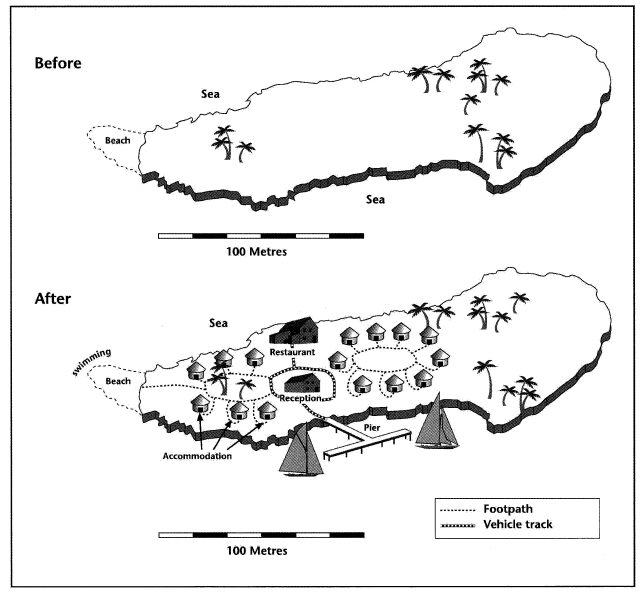
These two maps indicate the situation and development of an island before and after building several tourist facilities on it.

From the first map which shows the island with about 1.5-kilometre sea shore, there was a small range of beach on the west side of this island, without any facility but only some trees distributed on the west and near the center of the island.

The second map demonstrates the great changes of the island after tourist facilities being constructed on it. There are two accommodation units with footpaths connecting each hut. In terms of the beach, it has been used as a swimming spot with a footpath between it and one of the accommodation unit. A restaurant was built near the northern shore while a reception which is surrounded by a vehicle track is located near the center of the island. It can also be seen that there is a pier on the southern shore where people can go for sailing. There are also vehicle tracks linking the restaurant, the reception and the pier.

Overall, the maps show that not only were many tourism facilities constructed but the sea is also used for tourist activities.
 

teechar

Moderator
Staff member
Joined
Feb 18, 2015
Member Type
English Teacher
Native Language
English
Home Country
Iraq
Current Location
Iraq
These two maps indicate the situation and development of illustrate how an island looked originally before and how it changed after building several tourist facilities were built on it.

From the first map which shows the island with about 1.5-kilometre sea shore, there was a Originally, the island, which is about 250m in width and 50 m in length, had a small range of beach on the west side, of this island, without any facility but and only some trees distributed on scattered in the west east and a few in the west. near the center of the island.

The second map demonstrates the great changes of the island after tourist facilities being constructed on it. There are
As part of the development, two accommodation units clusters with footpaths connecting each hut were added. In terms of the beach, it has been used addition, the beach was designated as a swimming spot, with and a footpath between was added that connects it and one of to the western accommodation area. unit. A restaurant was built near the northern shore, while a reception which is surrounded by a vehicle track is now located near the center of the island. It can also be seen that There is now also a pier on the southern shore where people can go for sailing. Finally, There are also vehicle tracks linking the restaurant, the reception and the pier were also built.

[ 1] Overall, the maps show that not only were many tourism facilities constructed but the sea is also used for tourist activities.
-------------------------

[ 1]: This is meaningless, and it is the wrong place for the overall statement in task 1. If it is necessary to include an overall statement (e.g. when describing a graph), then put it after the introductory one.

Note also that you wrote 196 words. Aim for 150-180.
 
Status
Not open for further replies.
Top