hardyweineberg
Member
- Joined
- Jun 3, 2022
- Member Type
- Student or Learner
- Native Language
- Igbo
- Home Country
- Nigeria
- Current Location
- Nigeria
I wrote this essay:
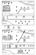
The maps illustrate Sawry District in 1920 and 2020.
Overall, a big office complex, apartment buildings and more road infrastructure have been added to the district.
In 1920, the district was divided into a northern and southern section by Oak Avenue, an east-west road that had shops and houses along it. Tulebug Bros. Cannery, a big factory with trees north and east of it, dominated the northwestern section, while the northeast had a side road with houses on its side and Elmwood River, which had a beach along it. In the southwest corner was Miller's Lake, with Prestwich Primary School north of it and many trees east of it. Furthermore, to the east of the school was an east-west side road connected to Oak Avenue.
By 2020, Yang Office Complex had replaced the factory, but the surrounding trees remained unchanged. In the northeast, houses were demolished so that the side road could be extended northward and so that an apartment building could be built along this road. Additionally, there was a bridge over the river and a bike path where the beach had been. Oak Avenue, the southern side road, and Miller's Lake stayed the same even though apartment buildings, more houses, and shops were constructed along this avenue. After the primary school was enlarged and relocated to the east of Miller's Lake, Lenoco Petrol Station was built in its former location; this relocation was made possible by clearing some southern trees.
No matter how hard I try to make mybmap descriptions concise, they are always more than 200 words long. The one above is 234 words, and I cannot identify the irrelevant details I included.
Please, give me tips on how to make my essays shorter, and point out the extraneous details in the essay above.